The Aigüestortes i Estany de Sant Maurici National Park (PNAESM) is the first and only National Park in Catalonia (created in 1955). The PNASM is one of the best-preserved examples of alpine ecosystems in the Iberian Peninsula, home to a remarkably rich flora and fauna typical of the alpine and subalpine zones. A distinctive feature of the PNASM is its remarkable diversity of aquatic ecosystems, or waterscapes. There are more than 200 lakes within its boundaries, a fact that makes the Park one of the most important alpine lacustrine districts of Europe. Since its beginnings, the LOOP has been in a close relationship with the Park, where part of its research has taken place. Since 2004, the LOOP carries out a monitoring programme in several lakes and streams of the Park. The LOOP is a founder member of the long term ecological research node LTER-Aigüestortes.
The National Park is in a high-mountain area, between altitudes 1,200 and 3,029 m. The climate is characterised by long harsh winters, with snow much of the year and temperatures easily fall below zero. The lakes freeze and nature is at rest. At lower valleys, snow is typically limited to winter months. Above 2,000 m, snow remains for many months, with some passes still covered in June. Summers, on the other hand, are short and cool, even cold at night. During the hot summer days the clouds often build up and result in heavy rain or electric storms. Changes in the weather are wont to be sudden, so it’s best to be prepared. The Park’s climate reflects valley orientation and altitude, creating distinct microclimates. Atlantic fronts bring humid conditions, greater rainfall, and frequent fog to north- and west-facing valleys, while east- and south-facing slopes show Mediterranean traits, with drier summers and less precipitation. In higher areas, conditions are more stable, with about 1,500 mm of rain and snow annually.
The Park is centred on a vast granite massif, around 300 million years old, exposed by tectonic uplift and erosion. Surrounding it are slates, limestones, and other sedimentary rocks, metamorphosed and folded during the Palaeozoic. Later, in the Tertiary, the Alpine orogeny further deformed and fractured these materials, shaping the Park’s present relief.
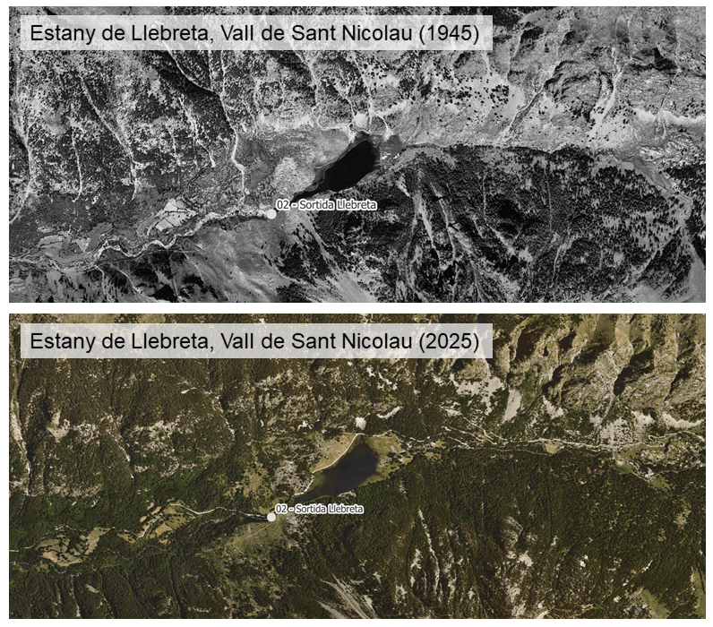
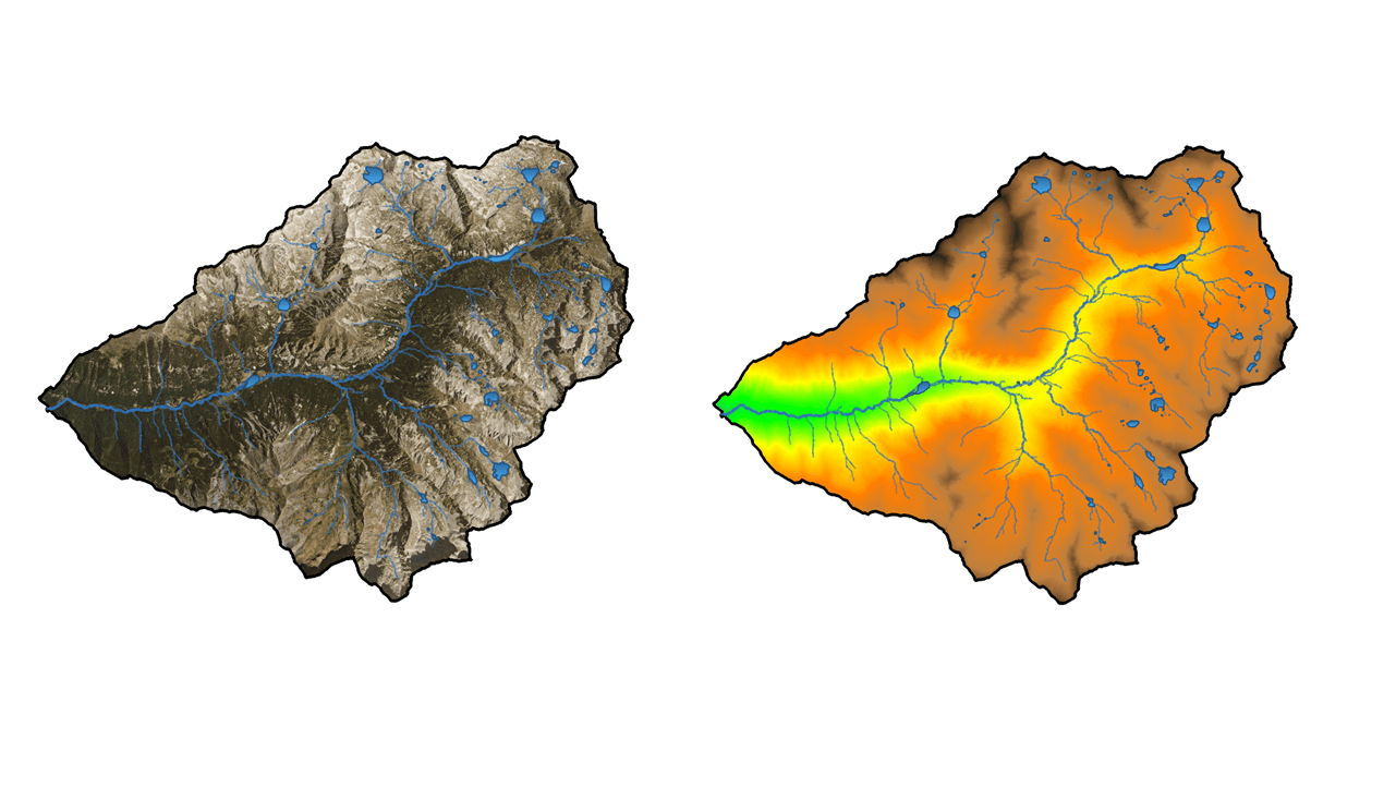
At the heart of the PNASM lies the Sant Nicolau Valley, a natural laboratory for the study of hydrological, ecological, and biogeochemical dynamics in high mountain areas. The site hosts numerous streams, from small alpine headwater channels to the larger riu de Sant Nicolau, which feeds into the Noguera de Tor southwest of the experimental valley. The Sant Nicolau experimental area covers 6,450 ha (64.5 km²) within a glacially carved valley oriented northeast–southwest. The valley features steep slopes and a mosaic of alpine meadows, forests, and lakes, and is fed by a series of sub-catchments draining from its north- and south-facing slopes. The valley extends from about 1,100 m at its entrance near the village of Boí, rises to the headwaters at Estany Llong (~2,000 m), and continues up to the surrounding cirques and ridges, such as Besiberri and Contraix, which reach 2,800–2,900 m.
The Sant Nicolau Valley has a typical high-mountain climate, with both subalpine and alpine zones. Snow and ice dominate for months: at lower elevations, they usually last only through winter, but above 2,000 m snow can persist until June. Summers are short and cool, often punctuated by sudden storms. Valley orientation adds further contrast, with Atlantic fronts bringing humidity and fog to north- and west-facing slopes, while south- and east-facing ones show drier, Mediterranean traits. In the highest areas, conditions are more stable, with around 1,500 mm of precipitation annually.
At the centre of the Sant Nicolau Valley lies a vast granite massif, about 300 million years old, exposed at the surface by tectonic uplift and erosion. As a conseuqnece, the predominant lithological unit is siliceous rock, mainly biotite and granodiorite, which makes up nearly 80% of the basin. These main lithologic units are surrounded by others—mainly sedimentary formations such as slate and limestone—that were metamorphosed and folded during the Palaeozoic.
The great altitudinal range of the Sant Nicolau Valley, creates a rich mosaic of vegetation habitats shaped by temperature, slope, orientation, wind, and soil. This results in clear altitudinal zonation: in the montane zone (up to 1,800 m) downy oak and beech forests have often been replaced by Scots pine, with pastures and hay meadows in the valley bottoms; the subalpine zone (to 2,300–2,400 m) is dominated by fir on shady slopes and mountain pine higher up, with undergrowth of rhododendron, bilberry, juniper, and broom, alongside clearings of birch, raspberry, and foxglove. Above 2,300 m, the alpine zone supports natural meadows of hardy grasses such as fescue and nard grass, dotted with alpine gentian, Pyrenean buttercup, and moss campion. The highest ridges, in the subnival zone above 2,700 m, are almost barren, with only specialised plants like mossy saxifrage surviving in cracks and ledges. Wetland habitats—lakes, springs, and marshes—add further diversity, hosting water crowfoot, orchids, and even carnivorous sundew
The Sant Nicolau Valley has been subjected to a wide range of natural and human disturbances, from changes in atmospheric inputs that alter the chemistry of its waters to shifts in chemical weathering dynamics driven by environmental factors, and, more recently, the impacts of climate change, such as altered precipitation patterns, droughts, pulsed rain events, and increasingly warmer winters. Superimposed on these pressures, hydroelectric developments in the lower part of the catchment have further reshaped patterns of connectivity and water flow . Within this context, a central focus of research in the valley is the study of the hydro-biogeochemical dynamics of its waterscape, encompassing both visible streams and lakes and the ‘invisible waters’ that circulate underground (so-called groundwater). The interplay between surface and groundwater systems not only shapes the valley’s landscape but also regulates nutrient cycles, water quality, and overall ecosystem functioning.
To monitor the hydro-biogeochemistry of the Sant Nicolau Valley, a network of sampling stations has been established across several experimental sub-catchments within the valley since 2004. More specifically, two different but complementary approaches are being applied to the study of the valley’s hydro-biogeochemistry, each corresponding to a distinct sampling strategy. The first is sensor-based monitoring, which provides continuous, high-frequency measurements of key variables and captures short-term dynamics. The second one is discrete water sampling based on field sampling campaigns, which involves periodic manual collection of water samples for detailed laboratory analyses, offering broader chemical and biological information but at lower temporal resolution. Together, these approaches provide a more complete understanding of the processes shaping the Sant Nicolau Valley.
One of LOOP most recent innovative goals is to leverage cutting‐edge sensor technologies to capture the rapid and non-linear nature of the mechanism underlying the transfer and cycling of water and biogeochemical elements across landscape compartments (atmosphere-groundwater-soils-surface water). In the Contraix experimental catchment (4.5 km2; 1967 and 2958 masl), several multi-sensor platforms have been deployed since 2020 to monitor the different compartments of the terrestrial–aquatic continuum. These platforms are equipped with stream gaging stations and complementary instruments to track the movement of water and solutes through fluvial ecosystems. They also include well networks with multi-sensor systems that autonomously collect subsurface hydrological and biogeochemical data throughout the hydrological cycle. Each network typically includes one deep well (extending up to 20 m) for sampling aquifers, two to three shallow wells (1–2 m) distributed along a hillslope–stream transect, and an array of three to five lysimeters installed in the upper soil layers (0.2–0.8 m).
For the discrete water sampling approach, three distinct sampling frequencies are used, each with a different spatial coverage. The regular or monthly sampling consists of frequent collections (e.g., weekly or monthly) to provide consistent time series of key chemical and biological parameters. Seasonal sampling is carried out at critical periods of the year—such as snowmelt, summer low flows, or autumn rains—to capture the influence of hydrological and climatic cycles on water quality. Annual sampling is conducted once a year at selected sites to obtain broader baseline information, enabling long-term comparisons and the detection of gradual trends in the watershed.